 in Irish Weather History 1")


Something Wintry This Way Comes: Long Range Forecasts Hint at Cold and Snow
As Ireland is preparing for its first cold spell of the 2025–26 winter, long-range forecaster Peter O’Donnell of Irish Weather Online is predicting a season with more wintry episodes than have been typical in recent years.
Vancouver-based O’Donnell, who gained national attention for his precise forecasting of the severe cold of November and December 2010, has been issuing daily long-range forecasts on Boards.ie under the name MT Cranium for almost two decades.
After examining global weather patterns and recent research, he believes “the coming winter will be relatively active one for Ireland and Britain, with some episodes of wintry cold and snow”.
He also expects one or two severe storms, driven by a strong jet stream across North America and the western Atlantic. His overall assessment is that the season will bring more genuine wintry episodes than have been seen in most recent winters, though a broadly severe winter remains unlikely. He suggests it may be classed instead as moderately severe.
Factors supporting a colder winter this year
Other long-range seasonal forecasts also point to an increased chance of colder than average conditions across Europe. Several atmospheric and oceanic factors support this possibility. These include a weak or negative phase of the Quasi Biennial Oscillation in the stratosphere, which often weakens the polar vortex and allows cold Arctic air to drift south. A weak La Niña in the tropical Pacific is another factor, as such events have historically been linked to more variable or colder winters in parts of Europe.
Seasonal forecasting remains uncertain, and although these signals increase the likelihood of colder conditions, they do not guarantee widespread cold. Not every disturbance of the polar vortex leads to severe weather in Ireland. The vortex is a band of strong westerly winds that forms high above the Arctic each winter. When it weakens, shifts or splits, the jet stream can become more erratic, allowing warm air to move into the Arctic and cold air to plunge south.
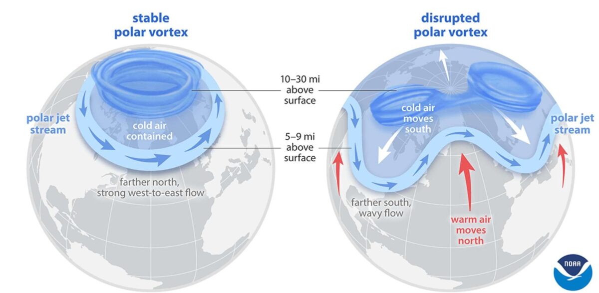
Sudden stratospheric warmings, which involve a rapid rise in temperatures high above the pole and a reversal of the vortex winds, are another important driver of winter weather. These events can trigger cold outbreaks across Europe, Eurasia and parts of North America. Around 25 major SSW events have occurred in the past four decades, but only a small number have led to severe cold in Ireland. The February 2018 warming resulted in the Beast from the East, while a January 2019 event left Ireland relatively mild. A warming in January 2021 brought colder conditions to Ireland and Britain, though it was far less severe than in 2018.
Other long range forecasts
Met Éireann, in its latest seasonal outlook for December, January and February, says there is a higher likelihood of cold spells than in recent winters, with all winter hazards possible and the greatest risk in December. Netweather.tv expects early December to turn drier and colder over the United Kingdom. Its monthly outlook notes that while early December is likely to be mild and changeable, there are signs of a return of a Greenland blocking high later in the month, increasing the chances of colder, drier weather and some snow, particularly on high ground and in northern and eastern Britain.
For the first ten days of December, the UK Met Office expects temperatures near or slightly above average, though short colder spells are possible if high pressure becomes established.
Meanwhile, Copernicus, the European Union’s Earth observation programme, has issued its latest outlook for the upcoming northern hemisphere winter.
The forecast highlights significant uncertainty around the atmospheric circulation patterns that will influence Europe’s weather in the months ahead.
However, the multi-system signal points to lower-than-average sea-level pressure over northern parts of the continent.
This pattern is consistent with a higher likelihood of milder-than-average temperatures across much of Europe and above-average precipitation in northern regions.
Share this WeathÉire story:

