 in Irish Weather History 1")


Caribbean Braced for Heavy Seas as Hurricane Erin Nears

Hurricane Erin, the first of the 2025 Atlantic season, is forecast to strengthen rapidly over the coming days as it tracks north of the Caribbean islands.
NOAA says the storm, currently packing sustained winds near hurricane force, could reach major hurricane status by the weekend and possibly Category 4 strength early next week.
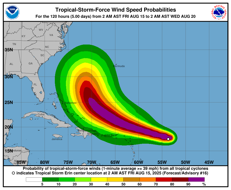
As of Friday, Erin was located about 550 miles east of the northern Leeward Islands. The National Hurricane Center expects it to pass just north of the Leeward Islands, the Virgin Islands and Puerto Rico. While the core is likely to stay offshore, outer rainbands may bring two to six inches of rainfall, gusting winds and large waves. Tropical storm watches are in effect for several islands.
Forecast models suggest Erin will curve northward between Bermuda and the east coast of the United States early next week. It is expected to remain well offshore of the mainland, although dangerous surf and rip currents could affect coastal areas from Florida to New England. Bermuda may experience stronger winds and heavy rain if the storm passes closer to the island.
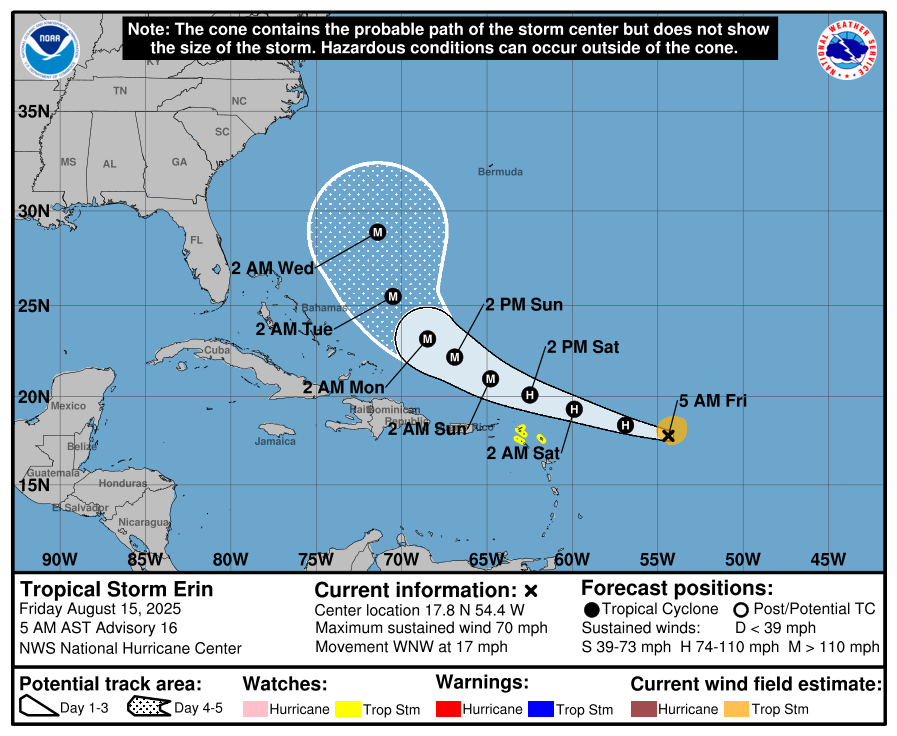
Forecasters caution that while confidence is high in Erin’s intensification and general northward track, small changes in atmospheric steering patterns could shift its path. Such changes could alter the extent of impacts for both island and coastal communities.
Residents and mariners across the Atlantic basin are being advised to monitor official updates from the National Hurricane Center in the coming days.
Hurricane Season 2025
The names for the 2025 Atlantic hurricane season are: Andrea, Barry, Chantal, Dexter, Erin, Fernand, Gabrielle, Humberto, Imelda, Jerry, Karen, Lorenzo, Melissa, Nestor, Olga, Pablo, Rebekah, Sebastien, Tanya, Van, and Wendy, according to NOAA.
The 2025 Atlantic hurricane season is forecasted to be above average, with meteorological agencies predicting increased tropical activity. The National Oceanic and Atmospheric Administration (NOAA) expects between 13 and 18 named storms this season, including 5 to 9 hurricanes and 2 to 5 major hurricanes reaching Category 3 or higher. This outlook reflects a 50% probability of above-normal activity, slightly reduced from an earlier forecast of 60%.
Colorado State University (CSU) maintains a similarly active forecast, projecting 17 named storms, 9 hurricanes, and 4 major hurricanes. Their prediction is based on warmer-than-normal sea surface temperatures and a shift to neutral El Niño–Southern Oscillation conditions.
AccuWeather forecasters also anticipate increased tropical storm formation, especially around mid-August, with three to five named storms expected across the Atlantic basin during that period.
Several factors are driving this elevated risk. Sea surface temperatures are currently 1 to 2 degrees Celsius above average, which, combined with reduced wind shear, creates favorable conditions for storm intensification. Additionally, the absence of El Niño this year further supports the likelihood of an active hurricane season.
Share this WeathÉire story:

