 in Irish Weather History 1")


Three new Atlantic weather systems monitored
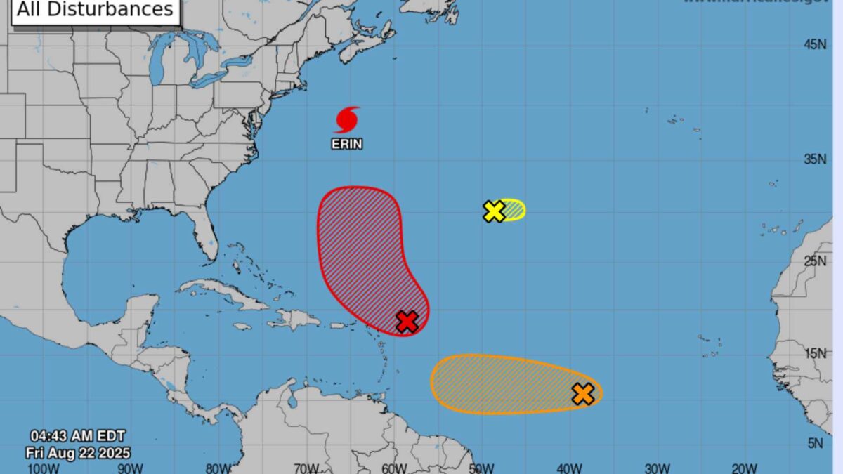
As Hurricane Erin begins to track towards the northeast Atlantic, positioning itself between Iceland and Ireland in the days ahead, the US National Hurricane Center (NHC) is keeping a close watch on three other potential storm systems emerging across the Atlantic.
The NHC said on Thursday that the most active of these disturbances is a tropical wave near the northern Leeward Islands. This system is expected to strengthen into a tropical depression over the weekend as it drifts between the Lesser Antilles and Bermuda. Forecasters have given it a 70 per cent chance of formation in the next 48 hours and an 80 per cent chance over the coming week.
Another tropical wave, located in the central Atlantic about 1,600km west-southwest of the Cabo Verde Islands, is producing well-organised thunderstorms. Although the system lacks a clear circulation centre, it could still develop into a depression. Conditions may become more favourable again early next week as it moves steadily westward at 15 to 25 km/h towards the Lesser Antilles. The centre gives it a 50 per cent chance of development within 48 hours and a 60 per cent chance within seven days.
A third system, a small low-pressure area southwest of the Azores, is less of a concern. It is moving through a dry environment with limited thunderstorm activity and forecasters expect it to dissipate in the coming days. Its chances of development are put at just 10 per cent.
The developments come as Hurricane Erin’s remnants are expected to bring more unsettled conditions to Ireland early next week following a spell of warm and dry weather.
Hurricane Season 2025
The names for the 2025 Atlantic hurricane season are: Andrea, Barry, Chantal, Dexter, Erin, Fernand, Gabrielle, Humberto, Imelda, Jerry, Karen, Lorenzo, Melissa, Nestor, Olga, Pablo, Rebekah, Sebastien, Tanya, Van, and Wendy, according to NOAA.
The 2025 Atlantic hurricane season is forecasted to be above average, with meteorological agencies predicting increased tropical activity. The National Oceanic and Atmospheric Administration (NOAA) expects between 13 and 18 named storms this season, including 5 to 9 hurricanes and 2 to 5 major hurricanes reaching Category 3 or higher. This outlook reflects a 50% probability of above-normal activity, slightly reduced from an earlier forecast of 60%.
Colorado State University (CSU) maintains a similarly active forecast, projecting 17 named storms, 9 hurricanes, and 4 major hurricanes. Their prediction is based on warmer-than-normal sea surface temperatures and a shift to neutral El Niño–Southern Oscillation conditions.
AccuWeather forecasters also anticipate increased tropical storm formation with three to five named storms expected across the Atlantic basin during that period.
Several factors are driving this elevated risk. Sea surface temperatures are currently 1 to 2 degrees Celsius above average, which, combined with reduced wind shear, creates favorable conditions for storm intensification. Additionally, the absence of El Niño this year further supports the likelihood of an active hurricane season.
More on Hurricane Erin.
Share this WeathÉire story:

