 in Irish Weather History 1")


Hurricane Gabrielle Strengthening as it Nears Bermuda
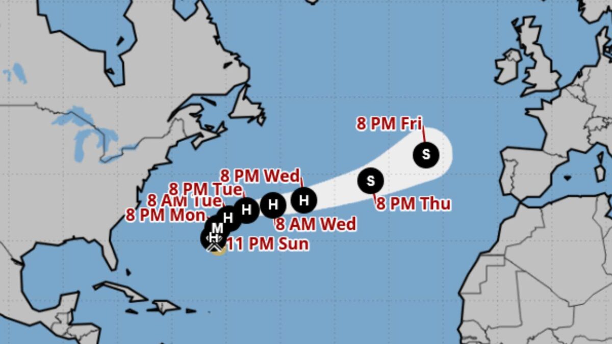
Hurricane Gabrielle, located about 425 km southeast of Bermuda on Monday morning, is forecast to turn northward during the day and rapidly intensify.
The U.S. National Hurricane Center said Gabrielle, with maximum sustained winds of 120 km/h, could become a major hurricane by Monday night.
At 3am GMT, Gabrielle was moving northwest at 12 mph (19 km/h). The storm’s centre is expected to pass east of Bermuda this evening.
Hurricane-force winds extend up to 35 km from the centre and tropical-storm-force winds extend outward up to 220 km. The minimum central pressure is estimated at 992 mb.
There are no coastal watches or warnings in effect, but authorities are urging Bermuda to monitor Gabrielle closely.
Large swells generated by the hurricane are affecting Bermuda, the U.S. East Coast from North Carolina northward, and Atlantic Canada. These swells will persist into early this week and could produce life-threatening surf and rip currents, according to the NHC.
Considerably uncertainty remains over the exact track of Hurricane Gabrielle, with some long range weather models indicating that its remnants may introduce unsettled conditions to Ireland by Friday afternoon.
NHC monitors two other systems
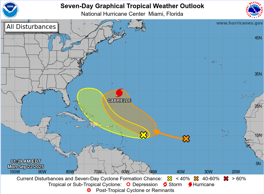
While Hurricane Gabrielle strengthens in the western Atlantic, forecasters at the U.S. National Hurricane Center (NHC) are monitoring two additional tropical waves for potential development this week.
In the central tropical Atlantic, a broad wave located well to the west-southwest of the Cabo Verde Islands is producing limited showers and thunderstorms. The NHC said dry air should suppress any significant development over the next day or two, but environmental conditions are expected to improve later this week. A tropical depression could form by the middle to latter part of the week as the disturbance moves west-northwestward to northwestward. The NHC gives the system a low 10 percent chance of formation within 48 hours but a medium 60 percent chance over the next seven days.
Further west, a second tropical wave positioned well east of the Lesser Antilles is bringing disorganised showers and thunderstorms. Conditions are only marginally favourable for development as it races westward at 15 to 20 mph. By late week, the system is expected to slow and curve more northwestward, passing north of Hispaniola. Even if the wave does not organise, the NHC warns of gusty winds and heavy showers for parts of the Leeward Islands late Monday night and Tuesday. Forecasters give it a low 10 percent chance of formation within 48 hours and a low 30 percent chance over seven days.
The developments come as the Atlantic hurricane season enters its traditional peak in mid-September, when ocean temperatures and atmospheric conditions typically favour storm formation.
2025 Atlantic Hurricane Season to date
The 2025 Atlantic hurricane season is proving quieter than anticipated, with activity so far falling well below early forecasts.
As of today, eight named storms have formed, but only two, including Gabrielle and Hurricane Erin, which reached Category 5, have intensified into a hurricane. No major hurricanes have occurred. This contrasts sharply with predictions issued earlier this year. Preseason forecasts by NOAA and Colorado State University anticipated 13 to 18 named storms and up to 10 hurricanes, with several expected to reach major hurricane strength.
Meteorologists attribute the subdued activity to a combination of factors, including strong vertical wind shear across the tropical Atlantic, persistent dry air, and a weaker-than-usual West African monsoon, which has limited the number of storm-forming disturbances entering the basin.
While the season has been quieter than expected, forecasters caution that the peak months of August and September remain active periods for Atlantic storms. Warm ocean temperatures and shifting atmospheric conditions mean additional storms could still develop over the coming weeks.
Share this WeathÉire story:

