 in Irish Weather History 1")


14 November 2002: The Day the Tolka Burst Its Banks

On this day (14 November) in 2002, Dublin awoke to one of the most disruptive flooding events in many years.
The rain that fell across the capital on 14 November was not a sudden, isolated downpour but the culmination of weeks of exceptional wet weather that left the ground saturated and the city acutely vulnerable. When the heaviest rain arrived, it had nowhere to go except into rivers, onto roads and, in many cases, into homes and businesses.
The meteorological story behind the event began long before the first drains overflowed. October 2002 had been extraordinarily wet across the Dublin region. Dublin Airport recorded 181 millimetres of rain, the second highest monthly total ever measured there. Casement Aerodrome logged its wettest month on record with 178.9 millimetres. Glasnevin, with records stretching back to the nineteenth century, registered its second wettest October. Soil moisture readings from early November showed the ground was effectively saturated, offering no remaining capacity to absorb further rainfall.
When November arrived, the pattern continued. Up to the morning of the 13th, rainfall totals were already approaching or exceeding a normal full month. By the time the main event began at around 7pm that evening, the Tolka catchment was primed for trouble.
What followed was a thirty-six-hour period of persistent and, at times, intense rainfall. Between 13 and 15 November, an average of around 80 millimetres fell across the Dublin area. The Phoenix Park measured 87.5 millimetres, Dublin Airport 85.4, Glasnevin 74.7 and Casement 72.1. The single day figure for the 14th was particularly striking: Dublin Airport recorded 74.6 millimetres in the 24-hour window, placing it among the top ten wettest days on record there.
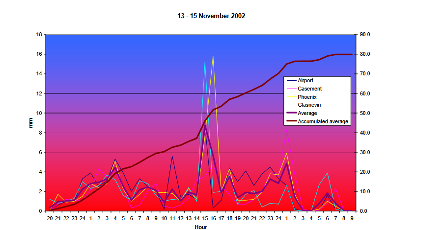
Rainfall charts from the period show multiple episodes of heavy precipitation, with hourly accumulations at Phoenix Park and Glasnevin repeatedly exceeding thresholds associated with significant runoff. Radar imagery from Dublin Airport indicated a large cyclonic area of rainfall centred between Wexford and Land’s End, with the most intense bands pivoting over or close to the capital. The pattern evolved slowly, with clusters of 16–32 millimetre six-hour accumulations appearing in different quadrants around the radar site from midnight through to the evening of the 14th. Although radar estimates have known limitations, particularly at close range, the persistence of these pockets aligned with the widespread ground-level reports of heavy rainfall.
As the rain continued, the River Tolka began to respond. Levels at the Botanic Gardens started rising late on the 13th. They reached an initial peak at around 7.30pm on the 14th, approximately four to five hours after the heaviest rainfall period. The river rose again later that night, reaching its overall crest at 1.45am on the 15th. By that stage, the Tolka had breached its banks in several locations, inundating roads and properties across the lower catchment.
Despite the disruption and damage that followed, the event was not unprecedented in the long-term statistical sense. Analysis of rainfall return periods shows that the twelve-hour totals observed in the Dublin area corresponded to events likely to occur roughly once every 20 years. The twenty-four-hour totals were more significant, with return periods in the range of 15 to 45 years depending on the station.
More from Met Éireann here or below and from Flood.info.
Share this WeathÉire story: in Irish Weather History 17")

