Hurricane Melissa To Pass Northwest of Bermuda, Steer Clear of Ireland
Bermuda is under a hurricane warning as Hurricane Melissa moves rapidly toward the island, with forecasters warning that hurricane conditions are expected to begin tonight.
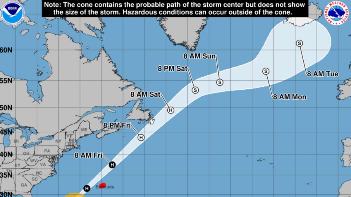
At 11am EDT (3pm GMT, the National Hurricane Center in Miami reported that Melissa was located about 515 miles (830 kilometres) southwest of Bermuda, moving north-northeast at 24 mph (39 km/h). Maximum sustained winds remain near 105 mph (165 km/h), making it a Category 2 storm on the Saffir–Simpson scale.
The centre of Melissa is expected to pass northwest of Bermuda later today and tonight, with tropical-storm-force winds reaching the island this afternoon. Residents have been urged to complete all preparations immediately.
Forecasters say little change in strength is expected today, though gradual weakening is likely to begin on Friday. Hurricane-force winds extend up to 75 miles (120 kilometres) from the centre, while tropical-storm-force winds reach outward up to 220 miles (350 kilometres).
Coastal flooding from storm surge is possible, and the outer rain bands could bring up to an inch of rainfall through tonight. Swells generated by the storm will reach Bermuda later today and are expected to cause dangerous surf and rip currents across parts of the western Atlantic, including the US East Coast and Atlantic Canada by Friday.
The storm’s minimum central pressure is estimated at 965 millibars (28.50 inches).
Melissa poses no threat to Ireland
Hurricane Melissa, which has caused at least 25 deaths in Haiti and widespread damage across Jamaica and Cuba, is weakening as it tracks northeast across the Atlantic.
By later this weekend the system will downgrade to an ex-tropical storm. Early next week it is likely to be situated between Ireland and Iceland, with no indication it will directly interact with the jet stream or pose a storm threat to the country.
The UK Met Office says Melissa will evolve into a “fairly typical autumn low-pressure system” next week.
Deputy Chief Meteorologist Tom Crabtree said: “Late on Sunday and into early Monday, a low-pressure system containing the remnants of what will then be ex-Hurricane Melissa will move across the far northwest of the UK. This appears to be a fairly typical autumn low-pressure system, introducing some milder air and bringing further spells of rain, heaviest over western hills.”
The chance of a named storm affecting Ireland next week remains low, but showers and occasional strong winds are likely across the island.
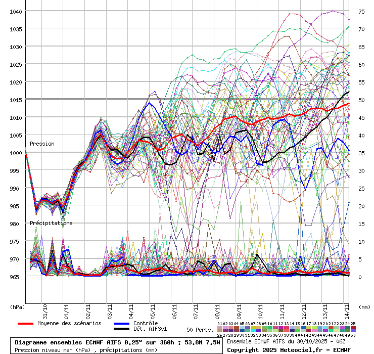
The red line in ensemble model forecast below shows the central trend, indicating ongoing wet and windy conditions, with potential for calmer weather after mid-November as air pressure rises.