 in Irish Weather History 1")


Erin Strengthens, Turns Toward North Atlantic
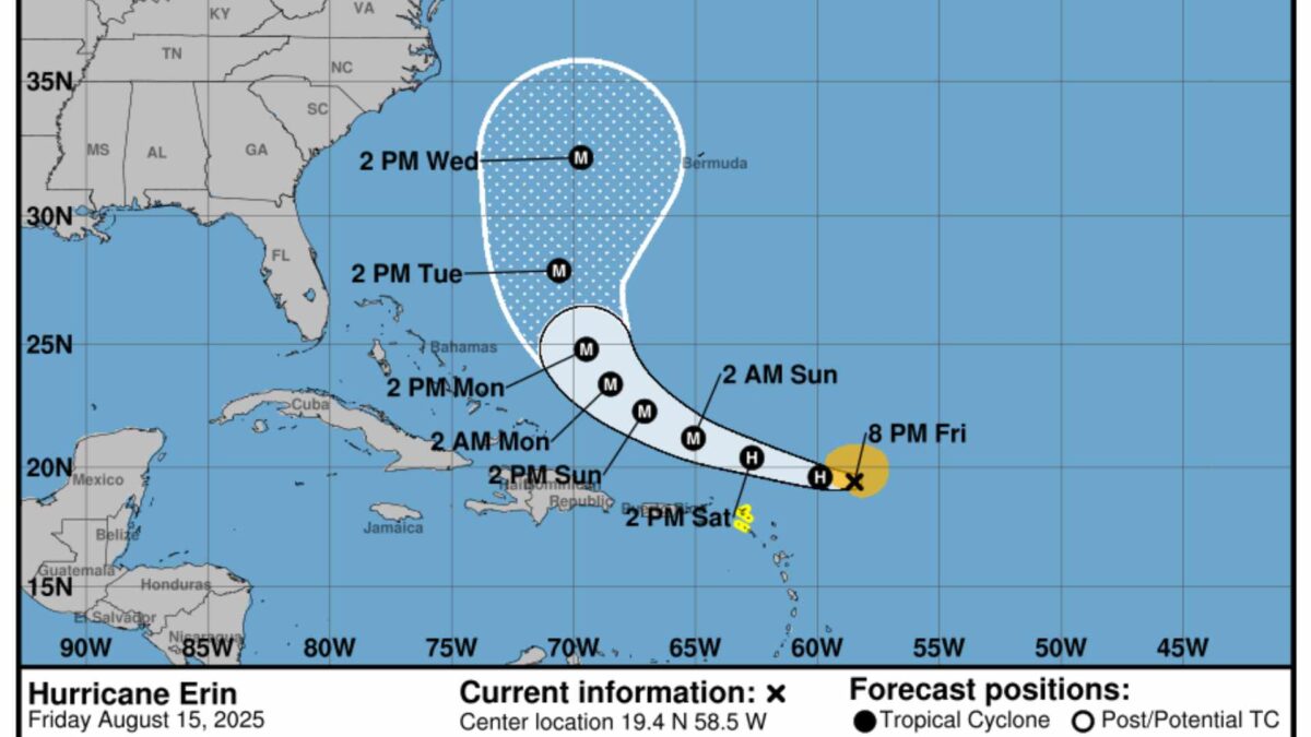
Hurricane Erin is continuing to intensify in the western Atlantic and is expected to become a very large and powerful Category 4 storm over the coming days, according to the US National Hurricane Center (NHC) and the National Oceanic and Atmospheric Administration (NOAA).
The system, currently carrying sustained winds of around 120km/h (65 knots), has shown signs of better organisation, with increasing convective banding near its centre and intermittent attempts to form an eye. Central pressure has dropped to about 993 millibars, although reconnaissance flights earlier today did not find an immediate increase in wind speed.
Erin is moving west-northwest at about 28km/h, steered by a subtropical ridge to its north. This general motion is expected to continue through the weekend, before a developing weakness in the ridge allows the hurricane to slow and begin turning northwards early next week. Forecast models are in good agreement on the storm’s path for the next three days, but some uncertainty remains on the precise timing and angle of the northward turn.
Sea surface temperatures along Erin’s projected track are between 29°C and 30°C, which will help fuel further strengthening. While mid-level dry air and Saharan dust to the north may limit rapid intensification, forecasters say the hurricane is likely to reach peak winds of 230km/h (125 knots) within 72 hours. Short-term fluctuations are possible due to eyewall replacement cycles.
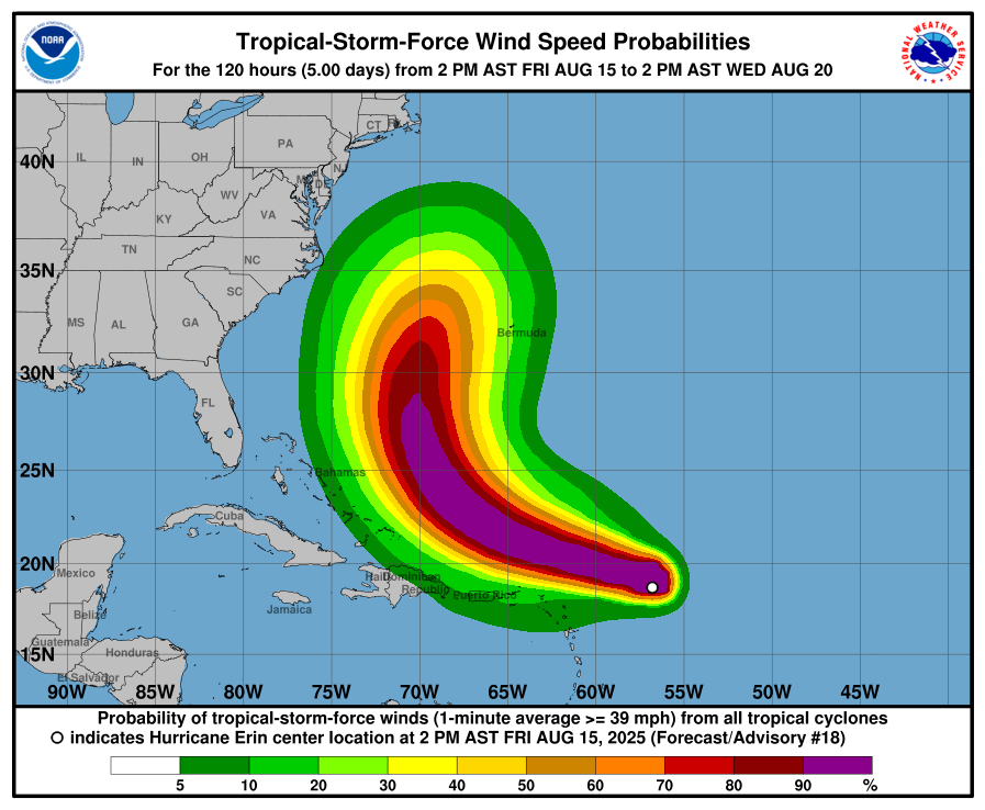
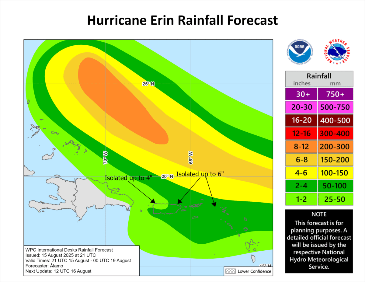
The NHC warns that Erin could produce heavy rain across the northern Leeward Islands, the Virgin Islands and Puerto Rico through Sunday, with the risk of flash flooding, landslides and mudslides. Tropical storm watches are in effect for parts of the northern Leewards, with the potential for gusts to tropical storm force over the Virgin Islands and Puerto Rico later in the weekend.
While the likelihood of direct impacts in the Bahamas and along the US east coast appears to be diminishing, dangerous surf and rip currents are expected along much of the western Atlantic coastline next week. Forecasters also advise that Bermuda remains at risk of strong winds, heavy rainfall and hazardous seas by midweek.

Hurricane Season 2025
The names for the 2025 Atlantic hurricane season are: Andrea, Barry, Chantal, Dexter, Erin, Fernand, Gabrielle, Humberto, Imelda, Jerry, Karen, Lorenzo, Melissa, Nestor, Olga, Pablo, Rebekah, Sebastien, Tanya, Van, and Wendy, according to NOAA.
The 2025 Atlantic hurricane season is forecasted to be above average, with meteorological agencies predicting increased tropical activity. The National Oceanic and Atmospheric Administration (NOAA) expects between 13 and 18 named storms this season, including 5 to 9 hurricanes and 2 to 5 major hurricanes reaching Category 3 or higher. This outlook reflects a 50% probability of above-normal activity, slightly reduced from an earlier forecast of 60%.
Colorado State University (CSU) maintains a similarly active forecast, projecting 17 named storms, 9 hurricanes, and 4 major hurricanes. Their prediction is based on warmer-than-normal sea surface temperatures and a shift to neutral El Niño–Southern Oscillation conditions.
AccuWeather forecasters also anticipate increased tropical storm formation, especially around mid-August, with three to five named storms expected across the Atlantic basin during that period.
Several factors are driving this elevated risk. Sea surface temperatures are currently 1 to 2 degrees Celsius above average, which, combined with reduced wind shear, creates favorable conditions for storm intensification. Additionally, the absence of El Niño this year further supports the likelihood of an active hurricane season.
More on Hurricane Erin.
Share this WeathÉire story:

