in Irish Weather History 1")


Hurricane Melissa eyes Bahamas and Bermuda, will not impact Ireland
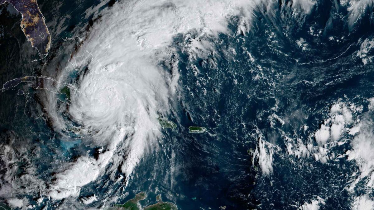
Hurricane Melissa is bringing destructive winds, torrential rain and dangerous storm surge to eastern Cuba as the powerful storm tracks towards the Bahamas and Bermuda. The system is not expected to impact northwestern Europe, including Ireland, however.
At 8am local time the centre of Melissa was located near Guantánamo in eastern Cuba with maximum sustained winds of 105 miles per hour. The US National Hurricane Center said the storm was moving north northeast at 14 miles per hour and would soon emerge into the Atlantic.
Hurricane warnings are in effect for the Cuban provinces of Granma, Santiago de Cuba, Guantánamo, Holguín and Las Tunas, and for the southeastern and central Bahamas.
A hurricane watch is in place for Bermuda, while tropical storm warnings have been issued for Haiti, Camagüey in Cuba and the Turks and Caicos Islands.
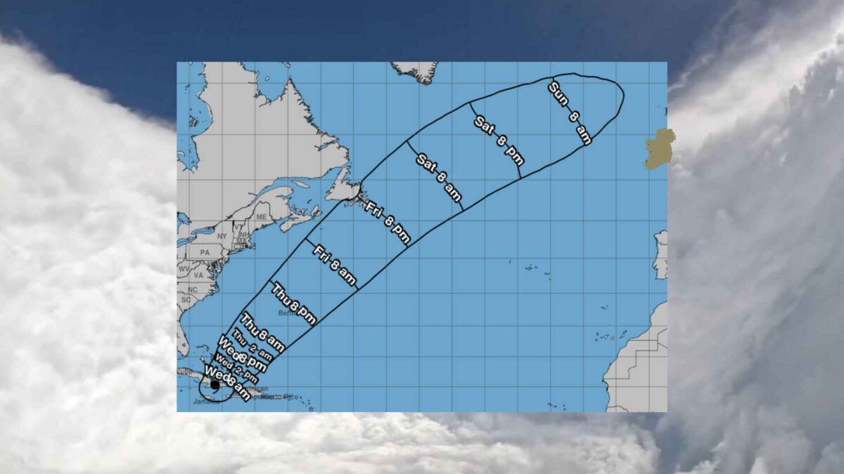
Melissa is expected to remain a powerful hurricane as it crosses the Bahamas later on Wednesday before passing close to Bermuda on Thursday night.
Rainfall of up to 25 inches is forecast in parts of eastern Cuba, bringing life-threatening flash flooding and landslides. Jamaica has already seen up to 24 inches of rain, with catastrophic flooding and numerous landslides reported. The Bahamas could see five to ten inches of rain, while Haiti and the Turks and Caicos face further heavy downpours.
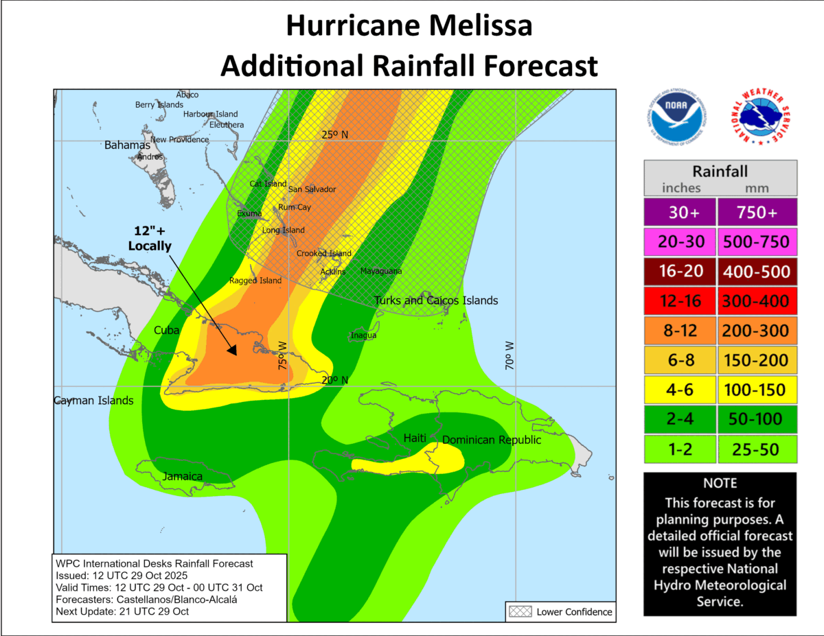
A storm surge of up to eight feet above normal tide levels is possible in the southeastern Bahamas, with minor coastal flooding expected in Cuba, Haiti and the Turks and Caicos. Rough seas and dangerous rip currents will affect much of the region.
Melissa has already caused extensive damage across parts of Jamaica and eastern Cuba. There are reports of power outages, washed-out roads and structural damage. Authorities in the Bahamas have urged residents to complete preparations and remain indoors as conditions worsen through Wednesday.
Melissa not expected to impact Ireland
By later this weekend, Melissa is expected to downgrade to an ex-tropical storm as it tracks north-east across the Atlantic.
Early next week the much weakened system is likely to be situated between Ireland and Iceland. At this stage there is no indication that it will interact with the jet stream or pose a storm threat to Ireland.
Ireland’s weather is expected to remain unsettled through much of next week, with a west to south-west Atlantic airflow dominating conditions. Showers or rain are likely on most days, accompanied occasionally by fresh to strong winds. The chance of a named storm is low at present.
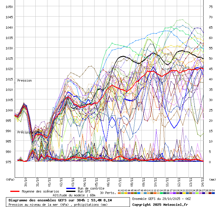
The red line in the GEFS graphic below shows the ensemble mean forecast, which represents the average of all ensemble members. It indicates the central trend and the most likely outcome amid uncertainty. It currently shows rainfall in Ireland on most days up to mid-November, with a trend towards slowly rising air pressure suggesting potentially calmer and more settled conditions after mid-month.