in Irish Weather History 1")


Hurricane Melissa lashes Jamaica as storm heads toward Cuba and the Bahamas
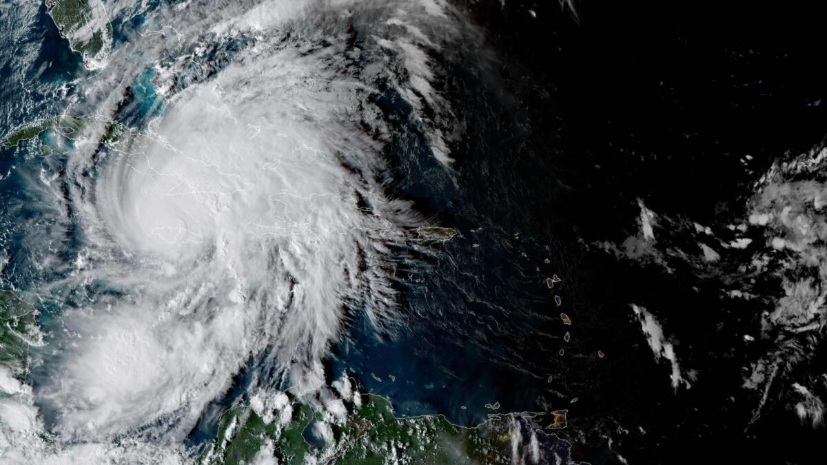
Hurricane Melissa has emerged from western Jamaica as a powerful Category 4 storm, bringing catastrophic flash flooding, damaging winds and a life-threatening storm surge.
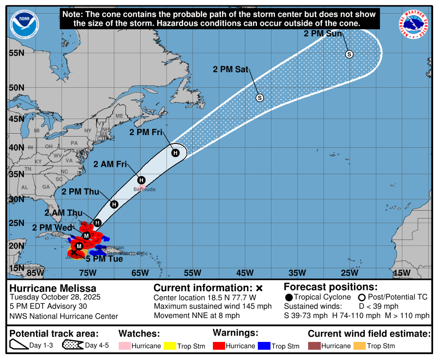
The centre of the hurricane was located near Montego Bay late Tuesday, moving north-northeast at 13 km/h. Maximum sustained winds were 230 km/h, with higher gusts reported.
The hurricane is expected to move over southeastern Cuba late Tuesday and into Wednesday, then across the southeastern and central Bahamas, and approach Bermuda by Thursday night. Hurricane-force winds extend up to 45 km from the centre, while tropical-storm-force winds reach 315 km.
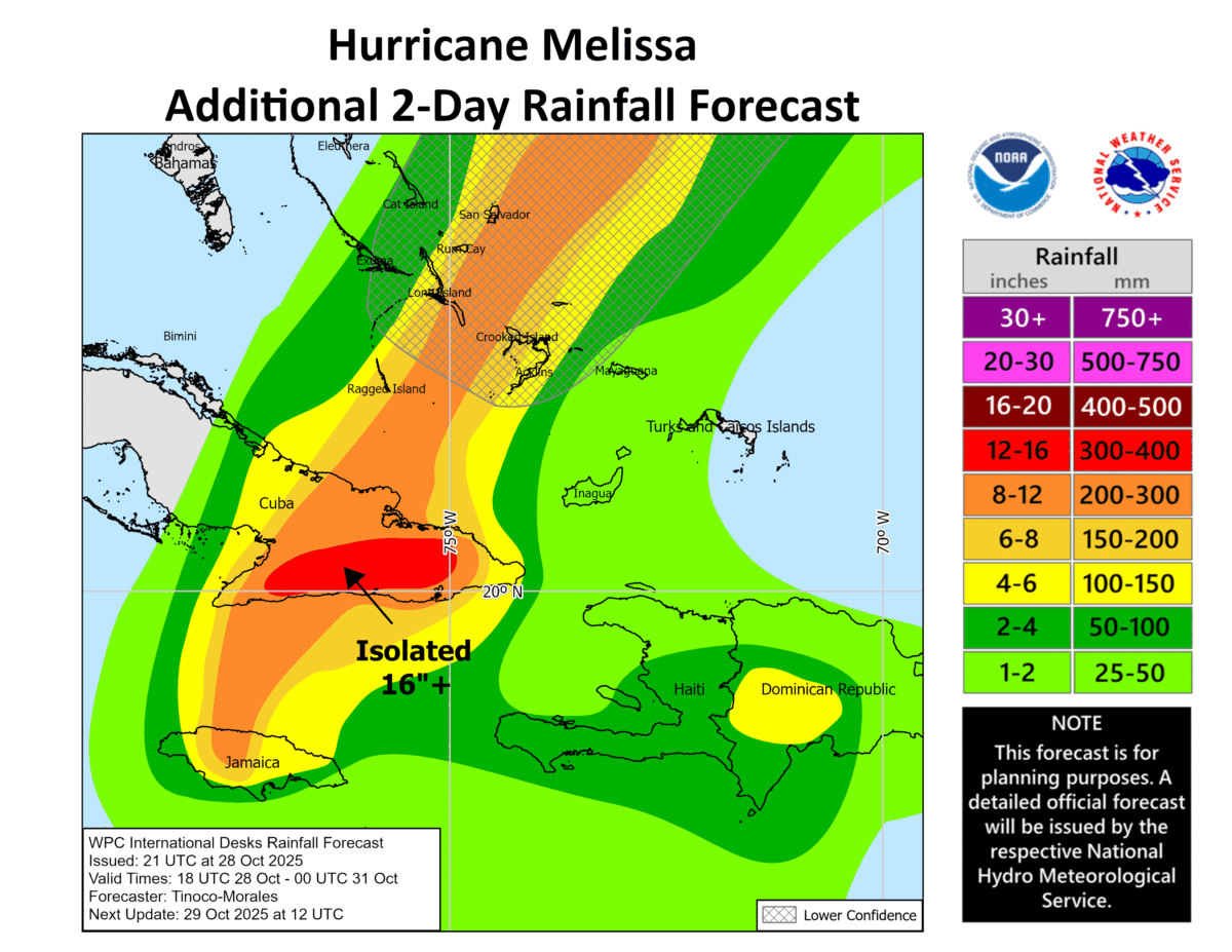
Jamaica remains under a hurricane warning, with rainfall totals expected to reach 300 mm in mountainous areas, triggering ongoing catastrophic flash flooding and landslides. Storm surge of 0.6 to 1.2 metres is possible along the northwest coast near Montego Bay.
Hurricane warnings are also in effect for the Cuban provinces of Granma, Santiago de Cuba, Guantanamo, Holguin, and Las Tunas, and for the southeastern and central Bahamas. Tropical storm warnings have been issued for Haiti, the Cuban province of Camaguey, and the Turks and Caicos Islands. A hurricane watch has been issued for Bermuda.
Melissa is expected to produce 250–500 mm of rain in eastern Cuba, with localised totals of up to 635 mm in mountainous areas, raising the risk of life-threatening flash floods and landslides. The Bahamas may see 125–250 mm of rain, while Haiti could receive up to 100 mm.
Officials have urged residents to remain in safe shelters and to prepare for widespread damage, particularly in coastal and mountainous areas. Dangerous surf and rip currents are expected across the region, extending later this week to Bermuda.
The National Hurricane Center and Air Force Reserve Hurricane Hunter aircraft are monitoring Melissa, which continues to pose a serious threat as it moves northeast across the Caribbean.
By later this weekend, Melissa is expected to downgrade to an ex-tropical storm as it tracks northeastward across the Atlantic. Early next week, the much weakened system is likely to be situated between Ireland and Iceland. There is no indication at this point that the system will interact with the jet stream to pose a storm threat to Ireland.