 in Irish Weather History 1")


Dry Spell to End Saturday as Rain Returns to Ireland

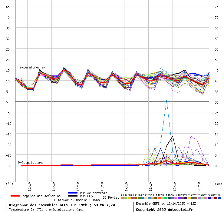
Ireland will remain mostly dry through the coming working week, with rain expected to return on Saturday. This marks the end of a 12-day stretch of dry but predominantly overcast conditions.
A low-pressure system currently positioned between Nova Scotia and Greenland is forecast to drift eastward across the Atlantic. Its remnants are expected to reach Ireland by Friday night, bringing rain first to the west coast before spreading east through Saturday.
Early indications suggest southern counties may see the highest rainfall totals, with some long-range models projecting up to 15-20mm. However, the exact location and intensity of the heaviest rain will remain uncertain until mid-week.
The Global Ensemble Forecast System (GEFS), which runs 21 simulations to account for uncertainty in atmospheric conditions, shows strong agreement for a return of rain on Saturday. The ensemble average, represented by a red line on forecast charts, points to a clear shift from dry to unsettled conditions.
Rainfall over the past week has been below average across the country. Malin Head recorded the highest total at 5.1mm, while Johnstown Castle in Co. Wexford saw just 0.3mm.
This dry spell follows an exceptionally wet start to October. In the first three days of the month, half of Met Éireann’s 24 synoptic stations recorded more than half their average monthly rainfall. Mace Head in Galway logged 74.2mm in 72 hours, representing 70 percent of its October norm. Athenry recorded 66mm, passing the halfway mark of its monthly average of 118mm.
Share this WeathÉire story:

