 in Irish Weather History 1")


Storm Erin Set to Become Major Hurricane
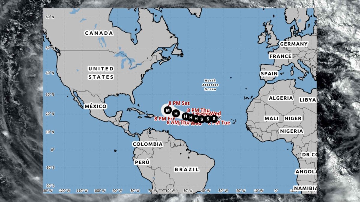
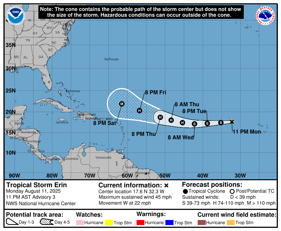
Tropical Storm Erin, currently churning in the central tropical Atlantic, is forecast to strengthen into a the first major hurricane of the season later this week. The US National Hurricane Center (NHC) predicts the storm could reach maximum sustained winds of up to 185 km/h (115 mph) by Friday.
As of 4am Irish time, Erin was located about 900 km west-northwest of the Cabo Verde Islands and roughly 3,255 km east of the northern Leeward Islands. Moving west at 35 km/h (22 mph), the storm is expected to slow slightly in the coming days while steadily intensifying over warmer waters.
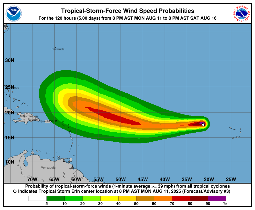
At present, Erin is generating sustained winds of 75 km/h (45 mph) with higher gusts. Tropical-storm-force winds extend up to 75 km from its centre. The minimum central pressure is estimated at 1004 mb.
Forecasters say conditions of low vertical wind shear will favour strengthening, though slightly cooler sea surface temperatures of 26–27°C may slow development in the short term. A more rapid intensification phase is expected once Erin moves into warmer waters.
Satellite imagery from NOAA’s GOES satellite shows the system rapidly intensifying in the Atlantic.
Potential Track
According to the National Oceanic and Atmospheric Administration (NOAA), “It is still too early to determine what impacts, if any, Erin may bring to the northern Leeward Islands, Bermuda, or the east coast of the United States. As we approach the climatological peak of the hurricane season, it is an opportune time to ensure your preparedness plans are in place.”
Current long-range forecasts suggest Erin poses no immediate threat to the US mainland. The American GFS model projects the system curving into the North Atlantic toward southern Greenland and Iceland. Meanwhile, the European ECMWF model brings the storm’s remnants closer to Ireland and Britain in 12–14 days, potentially coinciding with the 39th anniversary of Hurricane Charley on 25 August 1986.
It should be noted that model reliability drops significantly beyond five days, and the storm’s eventual path remains uncertain.
Hurricane Season 2025
The names for the 2025 Atlantic hurricane season are: Andrea, Barry, Chantal, Dexter, Erin, Fernand, Gabrielle, Humberto, Imelda, Jerry, Karen, Lorenzo, Melissa, Nestor, Olga, Pablo, Rebekah, Sebastien, Tanya, Van, and Wendy, according to NOAA.
The 2025 Atlantic hurricane season is forecasted to be above average, with meteorological agencies predicting increased tropical activity. The National Oceanic and Atmospheric Administration (NOAA) expects between 13 and 18 named storms this season, including 5 to 9 hurricanes and 2 to 5 major hurricanes reaching Category 3 or higher. This outlook reflects a 50% probability of above-normal activity, slightly reduced from an earlier forecast of 60%.
Colorado State University (CSU) maintains a similarly active forecast, projecting 17 named storms, 9 hurricanes, and 4 major hurricanes. Their prediction is based on warmer-than-normal sea surface temperatures and a shift to neutral El Niño–Southern Oscillation conditions.
AccuWeather forecasters also anticipate increased tropical storm formation, especially around mid-August, with three to five named storms expected across the Atlantic basin during that period.
Several factors are driving this elevated risk. Sea surface temperatures are currently 1 to 2 degrees Celsius above average, which, combined with reduced wind shear, creates favorable conditions for storm intensification. Additionally, the absence of El Niño this year further supports the likelihood of an active hurricane season.
Share this WeathÉire story:

