 in Irish Weather History 1")


The Big Freeze of 2010 remembered 15 years on
Today marks the fifteenth anniversary of the beginning of the The Big Freeze of 2010 that went on to be one of the harshest winters in modern Irish history.
The cold was driven by a strong blocking high-pressure system over Greenland and the North Atlantic, which forced the jet stream southwards. This allowed Arctic air to spill directly across Ireland and Britain. Northerly and easterly winds carried snow showers into coastal counties and set the stage for a prolonged period of sub-zero temperatures. Met Éireann has said the persistence of this blocking pattern was key to the severity and duration of the cold.
Snow showers swept across the country in the final days of November, signalling the start of a prolonged freeze. By the end of the month Dublin Airport had recorded minus 8.4 degrees and Casement Aerodrome minus 9.1 degrees, both the lowest November values ever measured.
December 2010 became the coldest December on record in Ireland. On 3 December Mount Juliet in Co Kilkenny registered minus 16 degrees. On 21 December Ballyhaise in Co Cavan recorded the coldest day ever observed at any Irish station, with a maximum of minus 9.4 degrees. On Christmas Day Straide in Co Mayo fell to minus 17.5 degrees, while Casement Aerodrome reached minus 15.7 degrees, the lowest value ever recorded in the Dublin area. Ballyhaise’s mean monthly temperature of minus 1.4 degrees was the lowest ever measured in Ireland for any month.
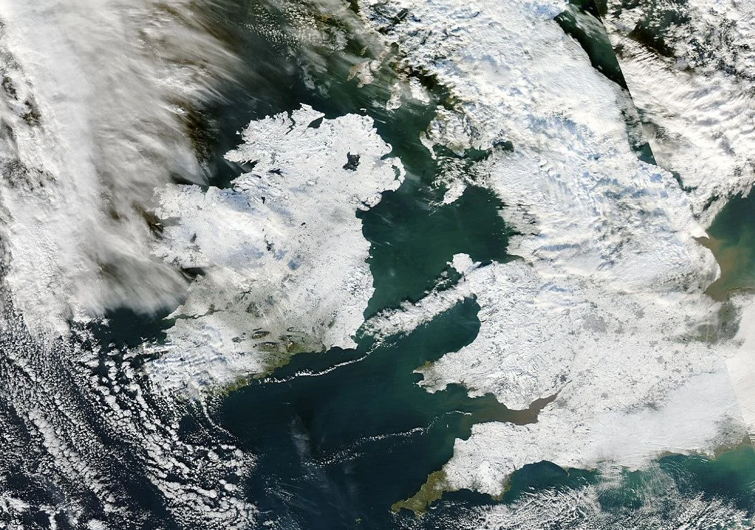
Snowfall was widespread and disruptive. Casement Aerodrome reported 27 centimetres lying on Christmas Day, while Dublin Airport measured 20 centimetres. Persistent snowfalls across Leinster and other regions caused major disruption to transport, schools and businesses. Soil temperatures fell below freezing at 20 centimetres depth at several stations, underlining the sustained nature of the cold.
Met Éireann described December 2010 as the most extreme cold spell in terms of depth of cold. While earlier winters such as 1962–63 and 1978–79 had greater snow depths, the combination of duration, severity and early onset made the 2010–11 event exceptional.
The impact was felt in every part of daily life. Dublin Airport was forced to close, rail services were suspended and thousands of motorists were stranded on icy roads. Schools across the country shut their doors and retailers reported sharp drops in footfall. The UK economy was estimated to have lost more than a billion pounds a day during the worst of the freeze. Dozens of lives were lost across Ireland and Britain due to accidents, hypothermia and hazardous travel conditions.
Cold Spell Timeline
November began unsettled and wet, turned progressively colder mid-month, and ended with record-breaking frosts and snow. December was the coldest on record, marked by extreme lows, widespread snow, and severe disruption, before a late thaw at year’s end.
November 2010
- Early November (1st–18th): Mild, wet and windy weather dominated, with deep Atlantic depressions bringing heavy rain, thundery showers and stormy seas on western coasts. Temperatures were above normal, with few frosts.
- Mid-November (19th–26th): An anticyclone developed, shifting winds to northerly and bringing colder, sunnier conditions. Frost became widespread, though rainfall was limited except for coastal showers.
- Late November (27th–30th): The anticyclone moved northwest, allowing a bitterly cold northeasterly airstream. Severe frosts, freezing fog and widespread snow followed. Temperatures fell below –6°C in many places, with Dublin Airport and Casement Aerodrome recording their lowest November values on record. Overall, it was the coldest November since 1985.
December 2010
- Overall: The coldest December on record almost everywhere in Ireland, with mean temperatures up to 6°C below normal. Straide, Co Mayo, recorded –17.5°C on Christmas Day, the lowest December temperature ever measured in Ireland. Ballyhaise, Co Cavan, set the record for the lowest monthly mean temperature of any month at –1.4°C. Snow lay up to 27 cm deep at Casement Aerodrome on Christmas Day. Rainfall totals were below average, but sunshine was well above normal in the west and southwest.
- 1st–8th: Northeasterly winds continued the late November freeze. Snow and sleet fell widely, with Mt Juliet, Co Kilkenny, recording –16°C on 3 December.
- 9th–15th: A brief milder spell under high pressure brought some thawing, though frost remained at night.
- 16th–25th: A cold front reintroduced Arctic air. Persistent freezing conditions and snow showers caused major disruption. Ballyhaise recorded a maximum of –9.4°C on 21 December, the lowest daily maximum ever observed in Ireland.
- 26th–31st: Heavy rain in the south and west brought milder Atlantic air, leading to a rapid thaw. The month ended damp, cloudy and foggy.
 in Irish Weather History 17")

