 in Irish Weather History 1")


Storm Amy set to track further north, strongest winds to remain offshore
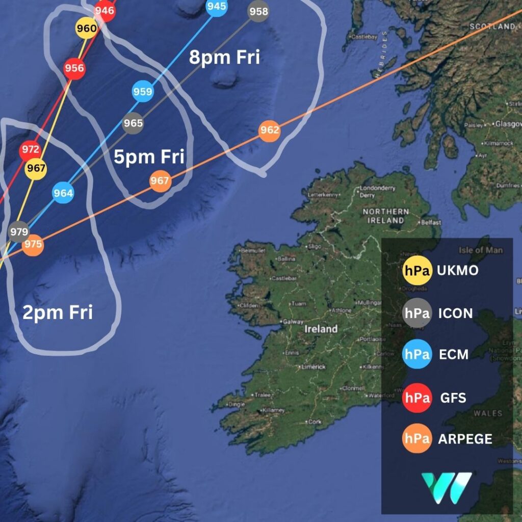
Weather models are increasingly pointing to a more northerly track for Storm Amy as it approaches Ireland and Britain on Friday.
This means the strongest winds are expected to remain largely offshore, although exposed coastal locations and high ground in the northwest and north of Ireland and northwest Scotland may still see significant gusts.
Overnight, computer models nudged the centre of the storm further north, leading to a reduction in the forecast maximum wind speeds previously expected for Atlantic coastal counties and across Ulster.
Of the main models, the French ARPEGE system presents the most disruptive scenario for Ireland, showing the storm’s centre tracking closer to Ireland’s northwest and north Scotland. Such a scenario could bring gusts of up to 130 km/h to the far northwest and north coast. Such a scenario, were to it to verify, would result in an upgrade in the existing Status Yellow warning in place for Ireland.
Met Éireann and the UK Met Office have both issued island-wide Status Yellow wind warnings from Friday through Saturday morning. According to Met Éireann, winds will reach strong to near-gale force at times, causing difficult travelling conditions, the possible displacement of loose objects, and a risk of fallen trees. The strongest winds are expected in the northwest and north of the country.
A separate Yellow wind warning from the UK Met Office covers Antrim, Armagh, Down, Fermanagh, Tyrone, and Derry, valid from 4 pm Friday until 6 am Saturday.
Both services advise the public to exercise caution, particularly on roads and in coastal areas, where conditions may be hazardous. A series of marine warnings has also been issued for all coastal waters.
In the meantime, Met Éireann has also issued a Status Yellow rain warning for large parts of the country on Thursday, with forecasters warning of the potential for localised flooding and difficult travel conditions.
The alert, which comes into effect at 6am on Thursday and remains in place until 8pm, applies to Cavan, Donegal, all of Munster and Connacht, as well as Longford.
According to the national forecaster, widespread rain, heavy at times, is expected throughout the day. The heaviest falls are likely in western and northern areas.
Met Éireann said the downpours could lead to hazardous conditions on the roads and localised flooding in parts of the country.
Hurricane Imelda
Meanwhile, Hurricane Imelda is forecast to bring hurricane-force winds, large waves and flash flooding to Bermuda later today, according to the US National Hurricane Center (NHC). Unlike the remnants of Hurricane Humberto, however, Hurricane Imelda is not expected to track northeast towards Ireland. The storm is forecast to accelerate northeastward after passing Bermuda and transition into an extratropical system in the coming days.


