Ireland Records Hottest Day of 2025 So Far

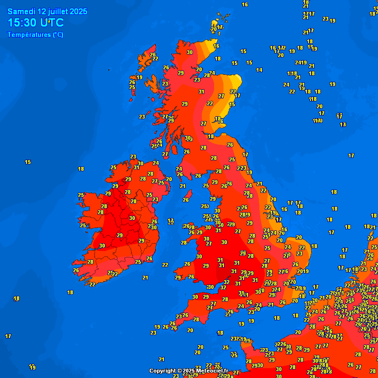
Both the Republic of Ireland and Northern Ireland experienced their hottest day of 2025 today.
Eglinton in County Derry reached a sweltering 31°C this afternoon, while temperatures at Mount Dillon climbed to 31.1°C. These highs surpassed the previous warmest readings of the year—29.6°C at Mount Dillon and 29.5°C at Castlederg in County Tyrone, both recorded on June 20.
Other highs included 30.2c at Oak Park in Carlow, and 30c at Shannon Airport and Mullingar.
With a Status Yellow High Temperature alert in effect nationwide, Saturday saw widespread heat, with temperatures reaching the mid to high 20s across all regions.

Met Éireann has issued two further Status Yellow warnings for Sunday as the hot weather begins to break down, ushering in increasingly unstable conditions.
A Thunderstorm Warning has been issued for Connacht, valid from 3pm to 10pm on Sunday. The national forecaster is warning of heavy, thundery downpours that could lead to surface water flooding, lightning strikes, hazardous driving conditions, and potential disruption to outdoor activities. The warning was issued on Saturday morning.
Meanwhile, a Status Yellow High Temperature Warning remains in place for several counties, including Carlow, Kildare, Kilkenny, Laois, Longford, Offaly, Westmeath, Cavan, Donegal, Clare, Limerick, Tipperary, and all of Connacht. This warning is valid from 12pm to 6pm on Sunday, with maximum temperatures expected to exceed 27°C.
Met Éireann has also flagged potential impacts including heat stress, an elevated fire risk in upland areas, and increased water safety concerns as more people flock to lakes, rivers, and beaches. This heat alert was issued on Friday morning.
The transition from extreme heat to thundery conditions marks the beginning of a more unsettled weather pattern.
Showery and sometimes stormy conditions are expected to continue through next week. Scattered showers and longer spells of rain—occasionally heavy and thundery—will occur daily.
Temperatures on Monday and Tuesday will fall to the mid to high teens, before gradually rising again later in the week to the high teens or low to mid-20s. High humidity may trigger further thunderstorms as the week progresses.
This unsettled, Atlantic-driven weather pattern is forecast to persist into next weekend and possibly beyond.
Share this WeathÉire story:


