 in Irish Weather History 1")


North Atlantic ‘Cooling Patch’ Could Grow by 2040

While global temperatures continue to climb, a curious exception is emerging in our part of the world — a region of the North Atlantic between Greenland and Ireland that appears to be cooling.
This anomaly, often referred to as the North Atlantic warming hole, stands out as a cool blue patch on global climate maps, in stark contrast to the widespread warming elsewhere. Despite the name, it’s an area where temperatures are actually dropping — and scientists say that trend may soon intensify.
A new study published in the Journal of Climate suggests that changes in wind patterns driven by climate change will begin reinforcing this cooling effect by around 2040. The research indicates that weaker winds could slow the vertical mixing of ocean waters, reducing the movement of warmer waters from below the surface and expanding the cooling zone.
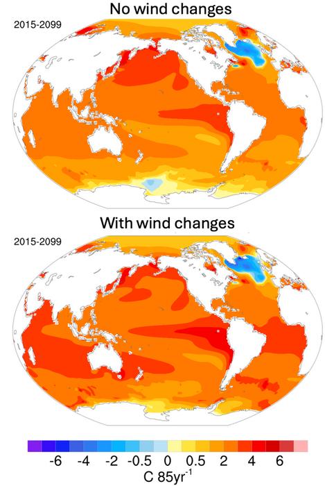
Kay McMonigal, the study’s lead author and assistant professor at the University of Alaska Fairbanks, explains: “Even though the planet is warming, this region is expected to keep cooling — and possibly even more so in the decades to come.”
The research team ran computer simulations exploring two future scenarios: one with shifting winds affecting ocean circulation, and one without. The models — based on moderate-to-high greenhouse gas emissions — showed that wind-driven cooling effects wouldn’t kick in immediately, but would likely become more noticeable around 2040, particularly between Newfoundland and Greenland. From there, the cooling signal could spread more broadly through the North Atlantic.
This evolving cooling patch could have significant knock-on effects for weather patterns across Ireland and Europe, including shifts in rainfall and temperature. Scientists are especially interested in understanding the warming hole because of its potential to alter regional climates in complex ways.
“There are a lot of implications for weather, especially over Europe,” McMonigal noted. “If we want to be able to predict things well, the winds need to be accounted for.”
The study was co-authored by Melissa Gervais of Pennsylvania State University and Sarah Larson of North Carolina State University.
Marine Heatwave Closer To Home
Last week, new data from the Marine Institute and Met Éireann revealed that the waters around Ireland are warming up much more than usual for this time of year.
In some places, sea surface temperatures (SSTs) are running between 0.6 and 2.2 degrees Celsius above the average for May.
The warmer waters are especially noticeable along the west and south coasts. Observations from the Irish Marine Data Buoy Observation Network (IMDBON) show a steady rise in temperatures throughout May, driven largely by a persistent area of high pressure that has dominated weather over northwest Europe this spring.
“This pattern has brought clear skies, lots of sunshine, and unusually light easterly winds,” explained Met Éireann climatologist Paul Moore. “These easterly winds are carrying warm air from land out to sea and limiting mixing with cooler water below—essentially allowing the ocean’s surface to heat up faster.”
Marine Heatwaves
Globally, marine heatwaves are being reported in several regions, but the warming off Ireland’s west coast is particularly striking.
Conditions here have remained stable and stationary—unlike other parts of the Atlantic—making the temperature spike more pronounced locally.
Share this WeathÉire story:

